Shushtar

Shushtar is one of the oldest cities in Iran, well known for its many historical and architectural wonders. It is located in the Khuzestan Province, approximately 92 kilometres of Ahvaz, and crosses the large river Karun (the ancient Pasitigris), Iran’s most effluent river. Known as Šurkutir in the Achaemenid period, the old city was situated on the Persian Royal Road which connected Susa, the capital of Elam, and Persepolis, the capital of the Achaemenids. Its modern name is connected to the city of Shush (the ancient Susa) and means “greater than Shush”.

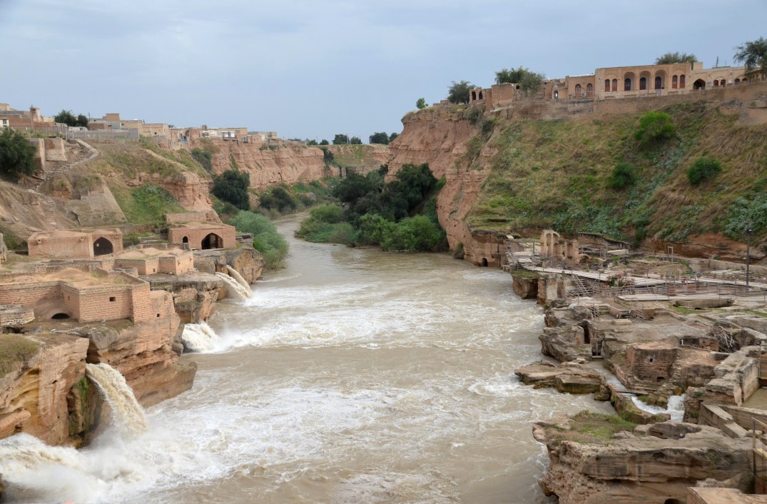
During the Sassanid era, Shushar was a fortified island town formed by the river Karun. The Sassanids, whose economy depended largely on agriculture, developed large irrigation systems in the region. They diverted the river Karun through large-scale civil engineering structures such as water canals, watermills and dam-bridges. One of these structures, known as the Shushtar Historical Hydraulic System, was registered in UNESCO’s list of World Cultural Heritage Sites in 2009, referred to “as a masterpiece of creative genius”. It comprises of fourteen mills and waterfalls flowing downstream from tunnels and cascading over rock cliffs.

In its present form, the Shushtar Historical Hydraulic System dates back to the 3rd century AD, but it was probably originally undertaken by Darius the Great, the Achaemenid king in the early 5th century BC.

After the defeat of Emperor Valerian who was captured with his entire army by the Sassanid ruler Shapur I in AD 260, numerous Roman soldiers were brought in to build and expand the irrigation system of Shushtar. They were also ordered to build a 500m-long dam-bridge, known today as Band-e Kaisar (“Caesar’s bridge”). The dam-bridge was used to control the powerful river Karun which raised and stabilised the water level by forming an impounding reservoir. Modelled on the Roman example, the arched superstructure was repaired in the Islamic period and remained in use until the late 19th century. It is considered today as being the easternmost Roman bridge.

Bridge-dam of Shâdorvân in 1880s, (Dieu la Foie and from the nomination file, SP of Iran)

For many centuries, the Shushtar multifunctional hydraulic system provided water supply to the city, operated a series of mills, irrigated vast farming zones, provided facilities for fish farming, river transport, and served as the town’s defence system. Several of these hydraulic functions are still in use.

Coordinates: 32° 2′ 44″ N, 48° 51′ 24″ E

PORTFOLIO

Links:

Bishapur

Bishapur was a Sasanian city in the Fars region of Iran, located on the road that connected the Sasanian capitals of Istakhr (close to Persepolis) and Ctesiphon. The site is known for its Sasanian-era bas-reliefs and the ruins of what was once a royal city. It was declared a UNESCO World Heritage site in June 2018 as part of the Sassanid Archaeological Landscape of Fars Region.

Coordinates: 29° 46′ 40″ N51° 34′ 15″ E

Bishapur was built near a river crossing in AD 266 on the orders of King Shapur I by Roman soldiers who had been captured after the defeat of the Roman emperor Valerian. The city, surrounded by walls that may have stood some ten metres high, was inhabited by some 50,000 to 80,000 people. It had a rectangular plan with a grid pattern of regular intra urban streets, resembling Roman city design. The Sasanian king had the sides of the nearby gorge decorated with huge historical reliefs commemorating his triple triumph over Rome.

Bishapur remained an important city until the Arab invasions and the rise of Islam in the second quarter of the 7th century. Under the Umayyads, the city became a centre of Islamic learning (a madrassah and a few mosques have been excavated).

PORTFOLIO

The city

The PALACE

The mosque

The reliefs

The first bas-relief

Badly damaged relief depicting the investiture of Shapur I. The king on horseback reaches for the beribboned ring held by Ahuramazda.
Detail of Roman emperor Gordian III who was mortally wounded during his campaign against the city of Ctesiphon in AD 244.
Right side of the badly damaged relief depicting the investiture of Shapur. Ahuramazda’s horse tramples upon the devil (Ahriman) and a kneeling Roman emperor (Philip the Arab) is shown pleading for mercy.

The second bas-relief

Relief depicting Shapur I’s investiture and his first victory over the Roman army. On the left two rows of advancing Persian cavalry and on the right two registers with delegates bringing objects

The third bas-relief

Relief depicting in five horizontal registers the triple victory of Shapur I over Gordian III, Philip the Arab and Valerian. The relief was damaged because of water erosion.

The fourth bas-relief

Relief made under Bahram II (r. 276-293) depicting the king receiving delegation of Arabs (the future conquerors of Iran) accompanied by a dromedary and a horse.

The fifth relief

Sasanian relief depicting the investiture of Bahram I (r. 273-276), the fourth Sasanian King of Kings of Iran.
Having lost Mesopotamia and Ctesiphon to the Romans, it is surprising to see Bahram represented as a victorious king trampling on a dead enemy with his horse. It is likely that the dead man did not belong to the original design and was added by king Narseh (r. 293-303) after a victory.

The sixth relief

Relief with two registers made for king Shapur II (r. 309-379), it depicts a triumph either over the Indians or the Kushans or the representation of the repression of a revolt.

Links: