Ambrussum

Ambrussum is a beautiful Gallo-Roman archaeological site which has revealed a great collection of buildings from the Gallic and Roman periods. It is close to the modern town of Lunel, located between Nîmes and Montpellier. The site is notable for its Iron Age settlement, its Roman staging post on the Via Domitia and its celebrated bridge spanning the Vidourle River, the Pont Ambroix.

Coordinates: 43° 43′ 12″ N, 4° 9′ 0″ E

Ambrussum

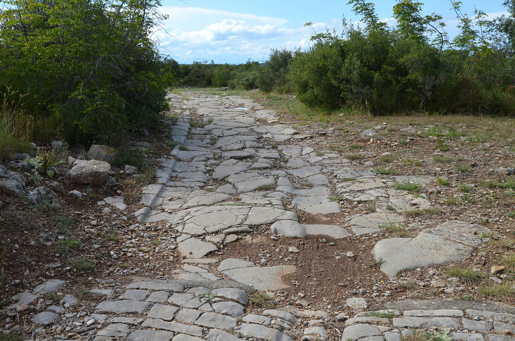
At the end of the fourth century BC a Gaulish tribe, the Volscians, settled and built a city surrounded by strong ramparts and towers (some of which can still be seen). The Romans conquered the area in 120 BC and the city grew rapidly. Thereafter, a new district was created next to the Vidourle River serving as a staging post for travelers (mansio). The Via Domitia, the oldest road built in France running from Alps to the Pyrenees, ran at the foot of the settlement. A paved road leading out of the settlement is visible along with the traces of Roman chariot tracks.

The Ambroix Bridge is unquestionably the most spectacular ruin of this ancient site. It is an impressive work of engineering, which allowed the Via Domitia to cross the Vidourle River. It is thought to have had 11 arches and to have been over 175 m (574 ft) in length. Unfortunately, the ravages of time and the numerous floods took out all but one arch. Two had stood as recently as 81 years ago — which are reflected in Gustave Courbet’s famous painting of the bridge — but a violent flood in 1933 left only one arch standing.

Portfolio

The remaining arch of Pont Ambroix, 1st century BC Roman bridge part of the Via Domitia.
A roadhouse along the Via Domitia dating back to around 30 BC, roadhouses were built every 10-15 kilometes along the Romans roads to allow travellers to rest.
The ruins of a roadhouse along the Via Domitia dating back to around 30 BC. Roadhouses were built every 10-15 kilometres along the Romans roads to allow travellers to rest.
The ruins of a roadhouse along the Via Domitia dating back to around 30 BC, roadhouses were built every 10-15 kilometres along the Romans roads to allow travellers to rest.
The ruins of a roadhouse along the Via Domitia dating back to around 30 BC. It contained everything needed to accomodate travellers: a hotel, several inns and a dwelling equipped with a forge for repairing vehicles, a bathouse and a small shrine.
The Via Domitia, the oldest road built in Gaul.
The paved way, the main artery of the city of Ambrussum.
The main artery of the settlement of Ambrussum was a paved road, dug out from deep ruts. Buildings (houses and shops) were built all along the sides of the road. The traces of Roman chariot tracks can still be seen.
The main artery of the settlement was a paved road, dug out from deep ruts. Buildings (houses and shops) were built all along the sides of the road.
The paved way at the south gate. The gates were enclosed within the city walls and served as the entrance to the city.
The terraced house in the northern district built in the Roman period.
A terraced house in the northern district built in the Roman period. Domestic life was organised around a courtyard bordered with an arcade. Each room had tiles floors and the walls were covered with painted plaster.
Another terraced house in the northern district built in the Roman period.
The ramparts of Ambrussum built in the late 4th century BC and modified in the mid-3rd century BC, they are the oldest visible remains on the hill, Oppidum of Ambrussum.
The ramparts of Ambrussum were built in the late 4th century BC and modified in the mid-3rd century BC. They are the oldest visible remains of the Oppidum.
Route of the Via Domitia.

See more images of Ambrussum on Flickr

Links:

Leave a comment

This site uses Akismet to reduce spam. Learn how your comment data is processed.