Shushtar is one of the oldest cities in Iran, well known for its many historical and architectural wonders. It is located in the Khuzestan Province, approximately 92 kilometres from Ahvaz, and crosses the large river Karun (the ancient Pasitigris), Iran’s most effluent river. Known as Šurkutir in the Achaemenid period, the old city was situated on the Persian Royal Road, which connected Susa, the capital of Elam, and Persepolis, the capital of the Achaemenids. Its modern name is derived from the city of Shush (ancient Susa) and means “greater than Shush”.
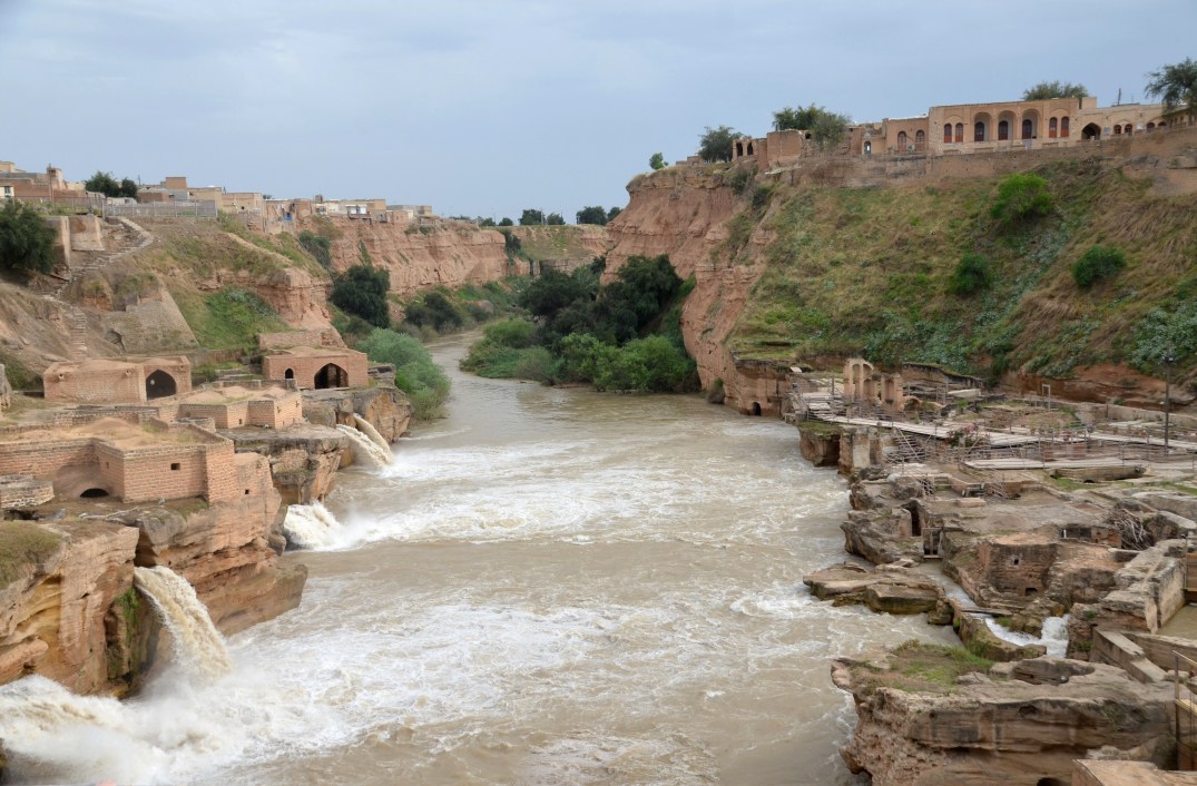
During the Sassanid era, Shushar was a fortified island town formed by the river Karun. The Sassanids, whose economy depended largely on agriculture, developed large irrigation systems in the region. They diverted the Karun River through large-scale civil engineering structures such as canals, watermills, and dam-bridges. One of these structures, known as the Shushtar Historical Hydraulic System, was registered on UNESCO’s World Cultural Heritage list in 2009, referred to as “a masterpiece of creative genius”. It comprises fourteen mills and waterfalls flowing downstream from tunnels and cascading over rock cliffs.
In its present form, the Shushtar Historical Hydraulic System dates back to the 3rd century AD, but it was probably originally undertaken by Darius the Great, the Achaemenid king in the early 5th century BC.
After the defeat of Emperor Valerian, who was captured with his entire army by the Sassanid ruler Shapur I in AD 260, numerous Roman soldiers were brought in to build and expand the irrigation system of Shushtar. They were also ordered to build a 500m-long dam-bridge, known today as Band-e Kaisar (“Caesar’s bridge”). The dam-bridge was used to control the powerful River Karun, raising and stabilising the water level by forming an impounding reservoir. Modelled on the Roman example, the arched superstructure was repaired in the Islamic period and remained in use until the late 19th century. It is considered today to be the easternmost Roman bridge.
Bridge-dam of Shâdorvân in the 1880s, (Dieu la Foie and from the nomination file, SP of Iran)
For many centuries, the Shushtar multifunctional hydraulic system provided water to the city, operated a series of mills, irrigated vast farming zones, supported fish farming and river transport, and served as the town’s defence system. Several of these hydraulic functions are still in use.
Chogha Zanbil is a magnificent, 3300-year-old ancient Elamite complex located 30 kilometres southeast of the ancient city of Susa in the Khuzestan province of western Iran. The principal element of this complex is an enormous brick ziggurat, a large stepped pyramidal temple dedicated to the Elamite divinity Inshushinak, the protector and patron god of Susa. The Chogha Zanbil ziggurat is considered the best-preserved and the finest surviving testimony to the once-great Elamite civilisation. In 1979, Chogha Zanbil became the first Iranian site inscribed on the UNESCO World Heritage List.
Chogha Zanbil was founded around 1250 BC by the Elamite king Untash-Napirisha as the religious centre of Elam. Its original Elamite name was Dur Untash, a combination of the Elamite Dur, meaning ‘place/resident/city,’ and Untash, the Elamite king who built it. The majority of people living there were probably priests or their servants.
The complex of Chogha Zanbil occupied a total area of 100 hectares. It consisted of a large, five-storey-high stepped pyramid temple, monumental palaces, temples, and tombs made from thousands of mud bricks of the same dimensions. Three concentric enclosure walls protected the entire complex, with an outer wall about 4 kilometres in circumference. The inner zone was centred on the ziggurat and included a series of temples and a large open courtyard. This central zone was enclosed by a wall that originally measured 520 metres and had six gates. The middle zone (temenos), which held eleven temples dedicated to lesser gods, was also surrounded by a wall that originally measured 1,625 metres long and 10 metres high. Four gates led from the temenos to the outer zone, with royal palaces and a funerary palace containing five subterranean royal tombs.
Hypothetical reconstruction of Chogha Zanbil.
The imposing ziggurat originally measured 105.2 metres on each side and stood about 53 metres high over five levels. It was crowned with a temple dedicated to Inshushinak. A single stairway in the middle of each of the ziggurat’s four sides led to the top of the first story. Only priests and royalty had access to the highest level. The site also featured an offering platform where bulls and goats would have been sacrificed. The ziggurat was faced with baked bricks, several of which bore cuneiform inscriptions naming deities in the Elamite and Akkadian languages. Every 11th row of outer bricks was stamped with an inscription. Only a few scribes would have been able to read them.
I, Untash Napirisha, king of Anshan and Susa, constructed the holy city of Untash Napirisha in which I built a golden temple tower enclosed within an inner and outer wall. I dedicated the city to Napirisha and Inshushinak. May these gods accept this, the fruit of my labor, as an offering.
— Inscription from Chogha Zanbil
Baked bricks with an Elamite inscription on the side surface of the ziggurat.
The complex was built on high ground, more than fifty metres above the nearby Eulaeus River (Dez), making bringing water to the city complex difficult. According to some scholars, Elamite architects and engineers constructed a long canal to supply the city with water. An ingenious system of reservoirs then distributed the drinking water throughout the city. To protect the ziggurat from torrential rainfalls and the inherent fragility of the bricks, the Elamite builders integrated a sophisticated drainage system into the ziggurat’s overall design.
Although construction in the city abruptly ended after Untash-Napirisha’s death, the site was not abandoned; it remained occupied until the Assyrian king Ashurbanipal destroyed it in 640 BC.
Choga Zanbil was discovered in 1935 during an aerial photography campaign conducted by geologists searching for oil in the region. The French archaeological team working in Susa
was informed of the discovery and identified the site as the sacred city of Dur Untash, described on brick inscriptions found locally. At this time, Dur Untash was named Chogha Zanbil, meaning “basket mound” and reflecting its shape. Choga Zanbil was excavated and restored in nine seasons between 1951 and 1962 by the distinguished French archaeologist Roman Ghirshman. Subsequent conservation work carried out by Iranian teams centred on the repair of the ziggurat.
PORTFOLIO
The protective wall of the middle zone with the ziggurat in the background.The southeastern gate of the protective wall of the middle zone (temenos).The Eastern Temples are constructed in sequence along the eastern edge of the middle wall.The Temple dedicated to Adad, the god of rain and thunder, and Shala, his spouse.View of the ziggurat from the northeast.The protective inner wall and gate lead to the inner zone of the complex.The entrance to the Inshushinak A Temple has an arched roof and a brick altar containing engravings on glazed bricks.The east side of the ziggurat.The Southeastern staircase provided access to the first terrace. On each side of this entrance, two terracotta statues of either a bull or a mythical lion-eagle existed.View of the central courtyard in the inner zone of the complex.The south side of the ziggurat.A round altar located on the southwestern side of the ziggurat was likely used for religious festivals.The Southwestern Stairway provided access to the top of the ziggurat.The temple complex is located inside the inner zone of the northwestern side of the ziggurat. These three temples were dedicated to Napirisha, Kiririsha, and Ishnikarab.This hatchet, inscribed with the name Untash-Napirisha, is dedicated to the goddesses Ishnikarab and Kiririsha. It was found in the Temple of Ishnikarab, Musée du Louvre. Photo: Rama [CC BY-SA 3.0 fr (https://creativecommons.org/licenses/by-sa/3.0/fr/deed.en)%5DThe northwestern side of the ziggurat.The Northeastern Stairway provided access to the first terrace.Bull with Elamite inscription from the northeastern entrance of the ziggurat. Dated to the late 2nd millennium BC. National Museum of Iran. National Museum of Iran [CC BY 3.0 (https://creativecommons.org/licenses/by/3.0)%5DView of the central courtyard in the inner zone of the complex.The northeastern stairway also provided access to the first terrace.The north side of the ziggurat.