Selinus is an ancient city located in the district of Antalya Province on the Mediterranean coast of southern Turkey, 180 km east of the city of Antalya. The history of Selinus goes back to the 6th century BC. Assyrian sources tell us that the city was originally called “Sallune” and was connected by a maritime trade route with the island of Cyprus. Selinus is best known for being the place of death of the Roman Emperor Trajan.
The ancient city of Selinus was established on the River Kestros (today called Hacımusa) in 628 BC, probably by Phoenicians and was then incorporated into the kingdom of Cilicia. The city stood on the slopes and at the foot of a steep hill with a perpendicular cliff on the seaward side and was surrounded by massive fortifications. In 197 BC the area passed into the hands of the Romans.
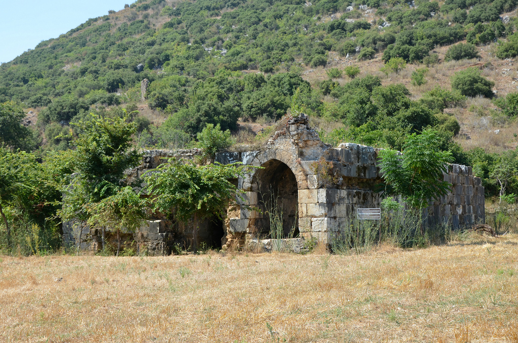
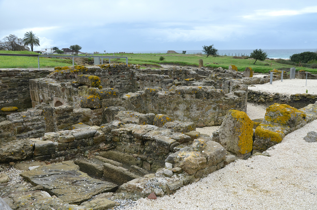
The remains visible today date to the Roman and medieval periods. The most interesting and best-preserved monument in Selinus is a large rectangular building locally know as Şekerhane Köşkü. It is located in a flat area at the foot of the hill, between the agora, bath house and odeon on its western side and the necropolis to the east. The monument has long been thought to have been built as a cenotaph for the Roman emperor Trajan.
The death of Trajan at Selinus on 8th August 117 AD later prompted the temporary renaming of the city as Trajanopolis. It also received the status of ius Italicum, transforming the provincial solum (land) into Italian solum, a rare privilege for a non-Italian community. A tetrastyle temple inscribed with the name TΡAIANO appeared thereafter on the city’s coins during the late 2nd and 3rd centuries.
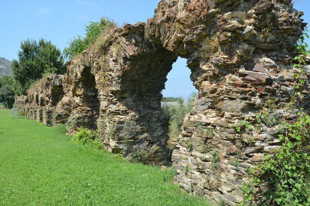
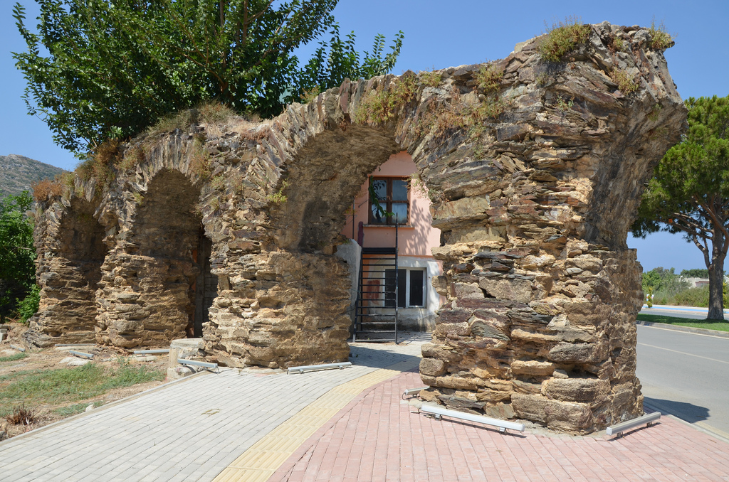
Near Trajan’s cenotaph are the remains of an odeon dating back to the Hellenistic era as well as baths from the Roman period. An aqueduct crosses the marsh near the mouth of the neighboring stream.
At its height, Selinus occupied an area of over 40 hectares and was the largest city in western Rough Cilicia. Selinus later became part of the Byzantine Empire alongside the rest of Cilicia. In the 12th century the Byzantines were succeeded by Armenian refugees who fled the Seljuk Turks invasion of Armenia and founded the Armenian Kingdom of Cilicia. At the end of the 13th century the city was incorporated into the Ottoman Empire.
Archaeological research Selinus has been conducted by a team from Florida State University. The founds are exhibited in the Alanya Archaeological Museum.
PORTFOLIO
The walls of the Acropolis fortress of Selinus and the harbour of Gazipaşa.Modern stairway going through the gate of the lower fortification walls.View of the so-called Şekerhane Köşkü from Selinus hill.The cenotaph of Trajan. The Imperial monument consisted of a central tetrastyle prostyle building (with four columns in front and two on the sides) of the Corinthian order with a cella and pronaos, on a high podium enclosed in a large temenos surrounded on all four sides by porticoes.The cenotaph of Trajan was remodelled by the Seljuks in the early 13th century using the ancient building materials which altered the monument in a structural way. The name Şekerhane Köşkü refers to the use of the building in Seljuk time as a hunting lodge.The remains of the Hellenistic odeon.The remains of the nymphaeum, part of the Large Bath Complex.The aqueduct of Selinus used to carry a steady supply of water to the bath from its presumed origin only 1,5 kilometres away and over the river.The remaining arches of the aqueduct.
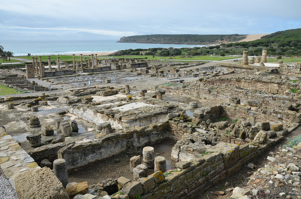
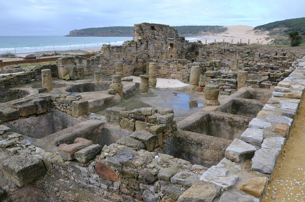
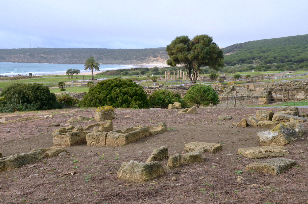
Baelo Claudia is an ancient Roman city lying on the shores of the Strait of Gibraltar in southern Spain. It was settled at the end of the 2nd century BC, and its history and subsequent development are closely associated with the salting industries and its maritime communication with North Africa. The ruins of Baelo Claudia, with its theatre, temples, forum and basilica, and especially its large fish-salting factory, testify to the city’s glory as an important and successful trading centre.
The Roman army landed on the shores of the Iberian Peninsula towards the end of the 3rd century AD in an attempt to halt the advancing Carthaginians, with whom they were engaged in a dispute for the control of the Western Mediterranean. The Roman victory at the Battle of Ilipa in 206 BC signified the end of the Second Punic War (218-202). The whole area was annexed under Augustus and became the most Romanised province in the Peninsula.
According to the oldest archaeological finds on this site, the prosperous city of Baelo Claudia was founded towards the end of the 2nd century BC. As shown in the legends of its Republican coins, the city was first known as Bailo. The abundance of fish in the Strait of Gibraltar facilitated the settlement of the coast and the exploitation of resources from the sea. During this period, the fish salting industries were established, and the city’s strategic position facing the North African coast led to its expansion as a trading centre.
Around the dawn of the new era, the city experienced a period of urban expansion while the first salting industries were rebuilt and made larger. Its strongest development was under the rule of Emperor Claudius (41-54 AD), who raised the city to the level of a Roman municipium with Roman rights. It was also at this time that Baelo received the name of Claudia. During this time, the city acquired a large forum with monumental public buildings, three aqueducts guaranteeing water supply to the population and two factories for the production of garum (fish sauce). The city walls that had been built a few years before during the reign of Augustus were also completely rehabilitated. The economic peak was maintained well into the 2nd century AD.
Model of Baelo Claudia.
However, economic activity started to decline at the beginning of the 3rd century AD, perhaps due to a major earthquake that occurred at the time and that may have destroyed most of the city. Also, the general socio-economic crisis that occurred in the empire during the 3rd century may have affected trade and commerce. The city experienced a slight recovery later in the century, but by the 7th century, the town was abandoned.
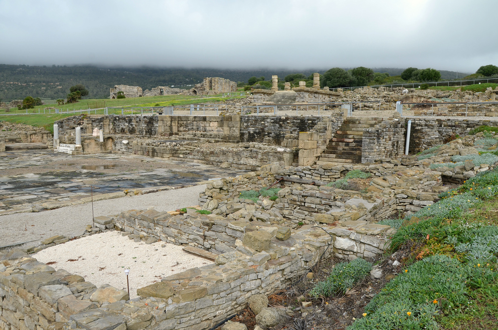
The excavations at Baelo Claudia have revealed the most comprehensive remains of a Roman town in the Iberian Peninsula. The site contains all the representative elements of a Roman city: the forum, temples, basilica, administrative buildings such as the curia, the marketplace, theatre, baths, industrial zone, and aqueducts. A modern Visitor Centre showcases many artefacts and offers a comprehensive introduction to the site.
PORTFOLIO
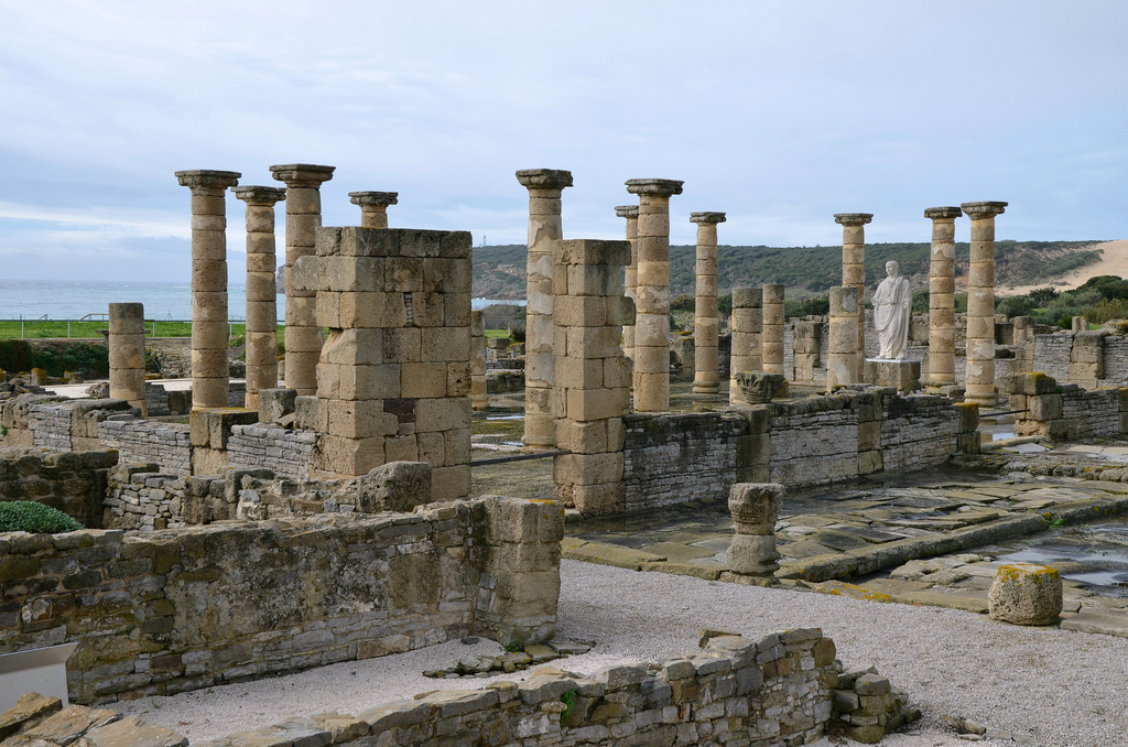
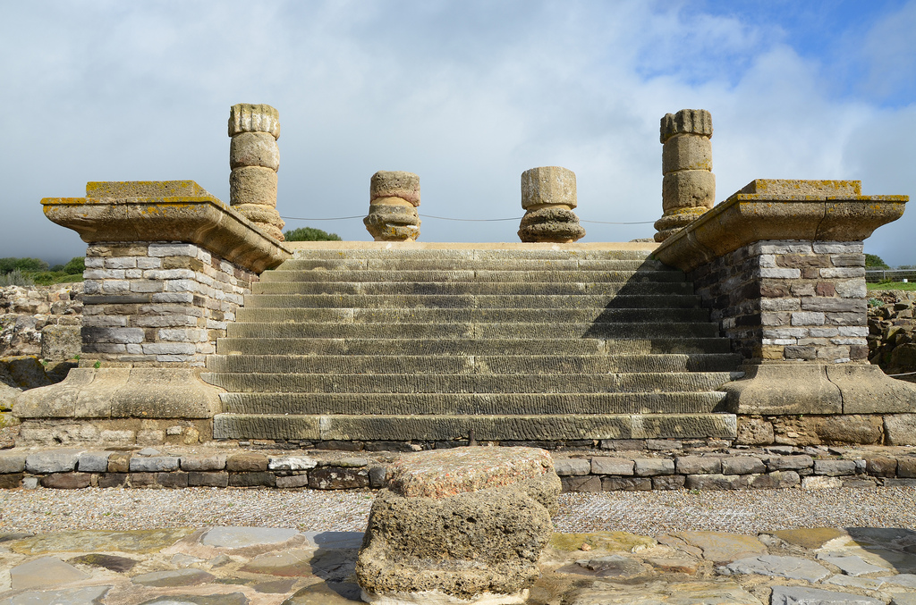
The Decumanus Maximus maintains its original flagstone paving. Along its length were shops, the public market building and the south side of the Forum. There were porticoes on either side.View of the Forum, the vital centre where administrative, political, judicial and religious activities were taking place. The Forum occupied a rectangular area of 115 x 87 metres.Although the original forum in Baelo dates back to the Augustan period, the nucleus of the forum area that we see today was remodelled between the years 50 and 70 AD (reigns of Claudius and Nero). The Forum is in very good condition and is the only completely excavated forum in Hispania.The Forum had porticoes on the east and west sides, with shops in the east part and administrative buildings in the west. To the south was the basilica, and to the north was a monumental fountain and a staircase leading to the Capitolium.The Basilica was one of the most important buildings in Baelo Claudia. It was built between 50 to 70 AD and was located in the main area where the city’s public life took place.The Basilica was built of ashlars and masonry walls, which were painted and stucco applied. A peristyle of twenty columns made up the inside space. It had two floors, the ground floor was of Ionic order and the top floor was of composite.The city of Baelo Claudia erected a colossal statue of Emperor Trajan and placed it in the Basilica on a pedestal clad with marble. The original statue is on display in the Museum of Cádiz.The South Square of the Forum. Behind the plaza are the Basilica, the Forum and the Capitolium.View of the Curia and the Macellum (the marketplace).The three temples of the Capitoline Triad are dedicated to Jupiter, Juno and Minerva. The Capitolium was constructed in the 1st century AD over a broad terrace that dominated the Forum.The Capitolium.The Temple of Jupiter was part of the Capitolium, the three tetrastyle temples dedicated to the Capitoline Triad (Jupiter, Minerva, Juno). The temples were separated by narrow corridors of similar dimensions. A share altar was in front of each temple.The podium of the Temple of Jupiter with 12 steps at the front and Corinthian columns.The thermal baths date to the end of the 1st century or the beginning of the 2nd century AD. They were in use until the end of the 4th century AD.The baths were accessed from the Decumanus Maximus. They included a “caldarium” (hot room), a “tepidarium” (tepid room) and a”frigidarium” (cold room).The industrial area is dedicated to the salting of fish and the production of the famous fish sauce, “garum”.The most valued and expensive product made in these factories was a fish sauce known as “garum”. A similar product, of a lower quality, was “liquamen”. These sauces could accompany all types of meals as a dressing or seasoning. It stimulates the appetite, and doctors usually recommend it due to its nourishing and curing properties.These are the large basins dug into the ground where the pieces of fish were piled up to be salted. The fish and salt were positioned in successive layers, taking approximately twenty days before the salting process was completed.The Theatre was constructed on a natural slope in the 1st century AD, around 70 AD. At the end of the 2nd century, it was no longer in use.The Theatre.The defensive walls were built during the Augustan period and were repaired and renovated with the same layout during the second half of the 1st century AD.Within the walls were the main entrances to the city.The Necropolis.The remains of the arches of the North aqueduct that supplied water to the buildings located in this area.

 The ancient city of Selinus was established on the River Kestros (today called Hacımusa) in 628 BC, probably by Phoenicians and was then incorporated into the kingdom of Cilicia. The city stood on the slopes and at the foot of a steep hill with a perpendicular cliff on the seaward side and was surrounded by massive fortifications. In 197 BC the area passed into the hands of the Romans.