The magnificent ruins of Persepolis, or Parsa, lie at the foot of the Kuh-i-Rahmat mountain, roughly 650 kilometres south of the capital city of Tehran and 70 kilometres northeast of Shiraz in the Fars region of southwestern Iran. Founded around 518 BC by Darius I (the Great), the site served as the ceremonial capital of the Achaemenid Empire. It was intended and designed to display the splendour and majesty of an empire that stretched from Greece to India. Sacked by Alexander the Great in 333 BC, the site lay hidden beneath sand until rediscovered in 1620. Persepolis was declared a UNESCO World Heritage Site in 1979.
Persepolis, a Greek toponym meaning “city of the Persians”, was known to the Persians as Parsa. It was a monumental complex of structures built by the great Achaemenid kings between 518 and 450 BC. An inscription carved on the southern façade of the Terrace wall of Persepolis and written in the three official languages of the Persian Empire – Old Persian, Elamite and Babylonian – proves that Darius the Great was the founder of Persepolis. Darius states that he built this fortress upon a place where no fortress had been before and made it secure and adequate.
A general view of Persepolis.
Construction began about 518 BC, as soon as work on Susa was finished. However, according to inscribed tablets found in the Treasury of Persepolis, the tremendous task was not completed until about 100 years later by Artaxerxes I (r. 465–424 BC). Darius began to build a massive terraced platform covering 125,000 square metres of the promontory. This platform supported four groups of structures: ceremonial palaces, residential quarters, a treasury, and fortifications. All these buildings were built of locally quarried stone, and architects and craftsmen from all over Persia’s Empire contributed to their construction.
Darius planned Persepolis as a showcase of the Empire, for it was here that ambassadors from all over the Persian world, from Ethiopia to Elam, would congregate each year to offer tribute to the king. The northern part of the Terrace comprised the official section of the Persepolis complex, accessible to a restricted public, including the Apadana, the Throne Hall, and the Gate of Xerxes (also known as the Gate of All Nations). The southern part held the Palaces of Darius and Xerxes, the Treasury, the Council Hall and the Harem. Darius constructed the platform, the monumental stairway, the Tripylon (or Council Hall), and his private Palace. He also carried out the first two building phases of the Treasury and began construction of the Apadana. Xerxes completed the Apadana, built the Gate of All Nations, his Palace and his so-called Harem, and started the Throne Hall (also known as the Hall of 100 Columns). Artaxerxes I completed the Throne Hall and began work on an unfinished porch that precedes it.
Plan of Persepolis. Encyclopædia Britannica Eleventh Edition, Vol. 2, Page 376
The function of Persepolis remains somewhat unclear. Most archaeologists suggest that the site had a sacred connection to the god Mithra (Mehr) and was mainly used to celebrate Nowruz, the Persian New Year’s festival held at the spring equinox. More general readings see Persepolis as an important administrative and economic centre of the Persian Empire.
Persepolis remained the centre of Persian power until the Persian Empire fell to Alexander the Great. The Macedonian conqueror captured Persepolis in 330 BC, and some months later, his troops destroyed much of the city. The lavish Palace of Xerxes was set alight, with the subsequent fire burning vast swathes of the city.
The ruins were not excavated until the Oriental Institute of the University of Chicago sponsored an archaeological expedition to Persepolis and its environs under the supervision of Professor Ernst Herzfeld from 1931 to 1934 and Erich F. Schmidt from 1934 to 1939.
PORTFOLIO
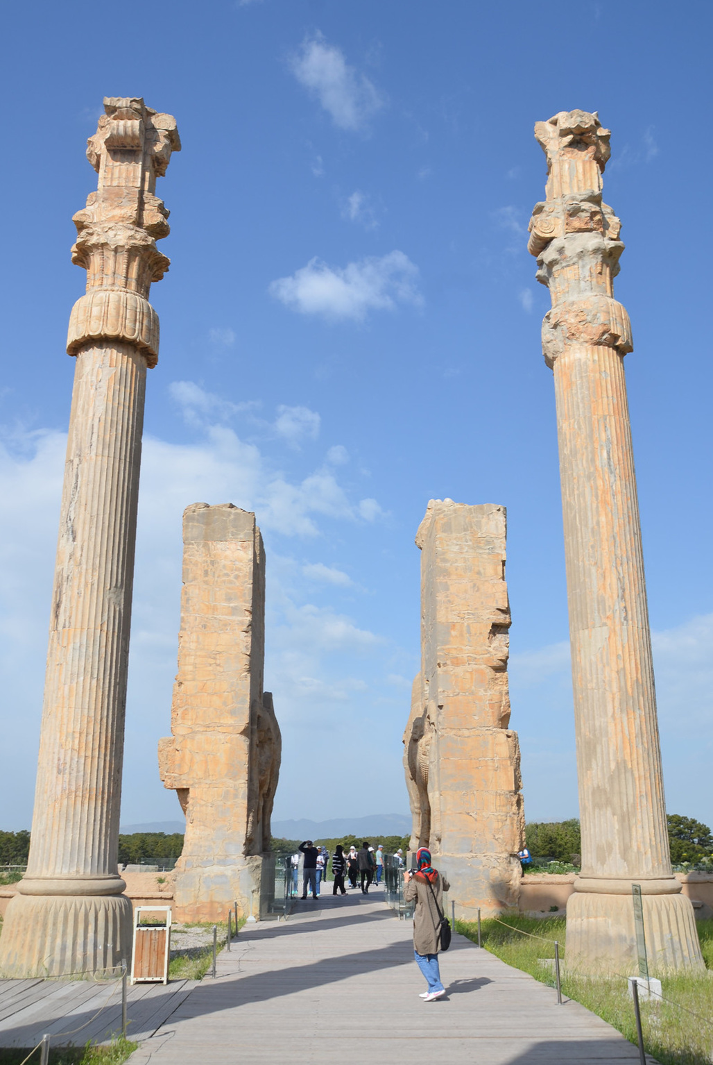
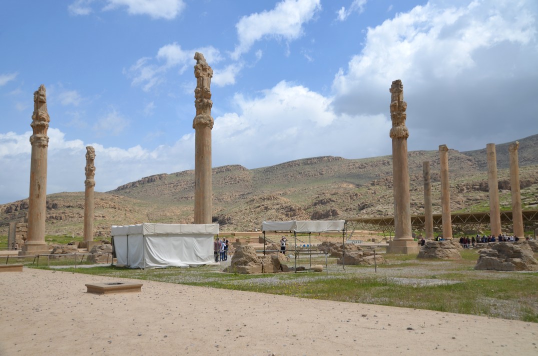
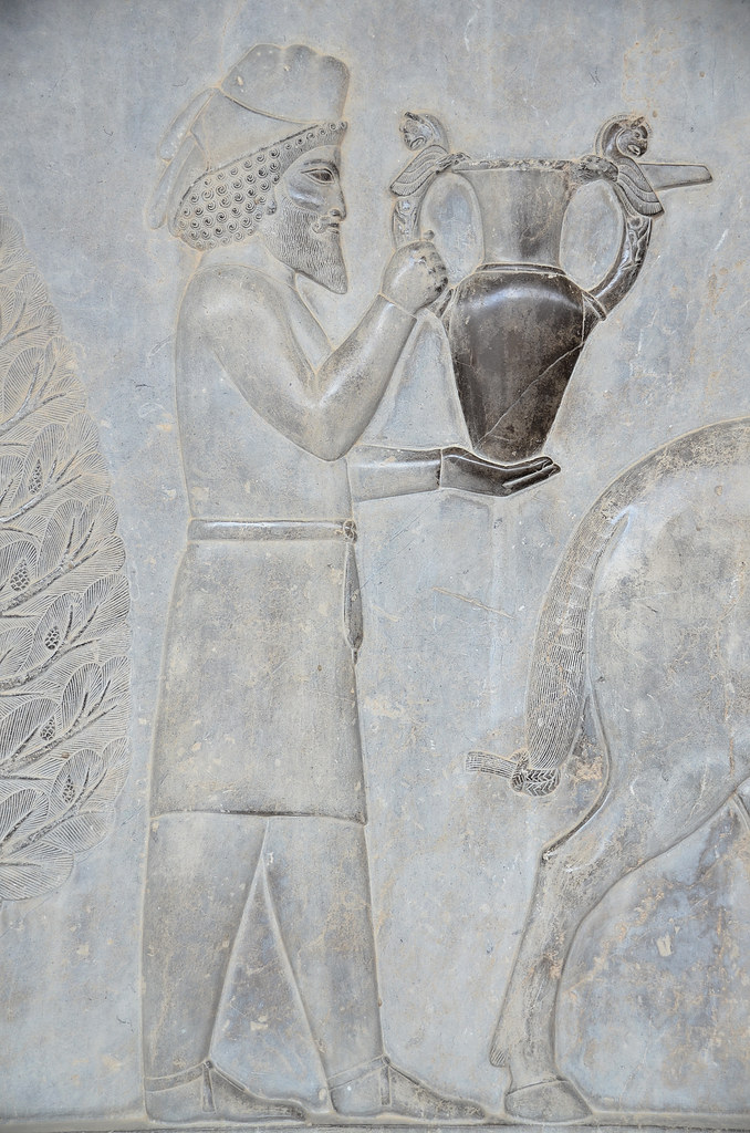
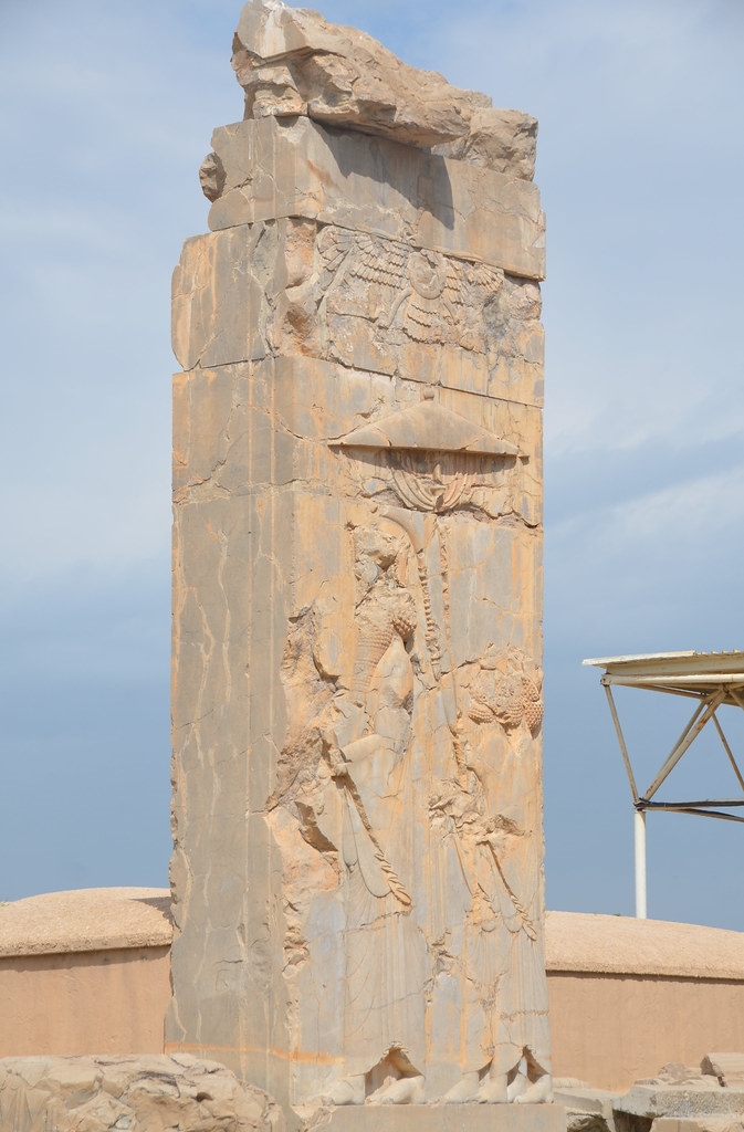
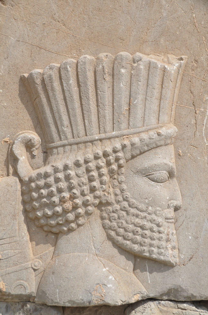
Part of the monumental double staircase leading up to the Terrace. Each flight has 111 steps, each 40 cm deep, 10 cm high, and nearly 7 m wide. The stairs were carved from massive blocks of stone, but each step was shallow, so Persians in long, elegant robes could ascend the 111 steps gracefully. The stairway was executed during the reign of Xerxes.The east side of the Gate of All Nations, also known as the Gate of Xerxes, was protected by two massive winged bulls with human heads called lamasssus.The Gate of All Nations was a structure consisting of a single spacious room, whose roof was supported by four stone columns with bell-shaped bases. It had two large doors, probably made of wood, on the south and east of the spacious room, indicating that the gateway was designed to give access to both the Apadana and the Throne Hall.The features of the four colossal figures were deliberately damaged by iconoclasts of the Islamic period.The stone columns of the Gate of All Nations were 16 metres high and were topped with capitals in the form of a double bull.Double-gryphon capital, locally known as “homa birds”, is probably from the Unfinished Gate.The Unfinished Gateway was begun by Artaxerxes I and may never have been completed. One entered a large court in front of the Throne Hall from its southern doorway. It had a central chamber with four columns and long, narrow rooms on its eastern and western sides.The northern entrance to the Throne Hall. It had a portico with two rows of eight columns, flanked by end walls featuring colossal bulls.The interior of the Throne Hall. The hall was 68m², and its floor was supported by ten rows of ten columns, each of which rose to 8 metres (less than half the height of the Apadana columns).The Throne Hall had eight stone doorways decorated on the south and north with reliefs of throne scenes and on the east and west with scenes depicting the king in combat with monsters.Throne scene relief on the southern doorway of the Hall of Hundred Columns (Throne Hall) depicting an enthroned king and attendant.Adjacent to the Throne Hall is the Treasury, part of which served as an armoury, especially as a royal storehouse of the Achaemenian kings.The tremendous wealth stored in the Treasury came from the booty of conquered nations and from the annual tribute sent by the peoples of the Empire to the king on the occasion of the New Year’s feast.Two large stone reliefs were discovered in the Treasury that depict Darius I, seated on his throne, being approached by a high dignitary whose hand is raised to his mouth in a gesture of respectful greeting. One of the reliefs is now in the National Museum of Iran.The Apadana was the largest and most magnificent building of Persepolis, located on the western side of the platform. It was begun by Darius, finished by Xerxes, and used mainly for great receptions by the kings.Thirteen of the Apadana seventy-two columns which supported the roof still stand. On top of the columns were capitals, consisting of two heads of fierce animals, such as bulls or lions. Between the two heads was the place where the wooden beams could rest.The monumental eastern stairway of the Apadana was adorned with relief registers depicting representatives of the twenty-three subject nations of the Persian Empire bringing valuable gifts as tribute to the king.Relief on the northern wall of the east stairway of the Apadana depicting a procession of dignitaries.Relief on the southern wall of the east stairway of the Apadana depicting Lydians who offer vases, cups and bracelets and a chariot drawn by horses.Relief on the southern wall of the east stairway of the Apadana depicting Syrians who offer two beautiful rams.Relief on the southern wall of the east stairway of the Apadana depicting an Armenian tribute bearer carrying a metal vessel with Homa (griffin) handles.Relief on the southern wall of the east stairway of the Apadana depicting Scythians, all armed and wearing the appropriate headgear, who offer a bracelet and folded coats and trousers.Relief on the southern wall of the east stairway of the Apadana depicting Arabians offering textiles and accompanied by a dromedary.Relief on the southern wall of the east stairway of the Apadana depicting Ionian Greeks carrying what may be beehives and skeins of coloured wool.A general view of Persepolis with the Hall of 100 Columns in the foreground and Apadana in the background.The ruins of the Tripylon (or Council Hall) connected the Apadana and the Hall of Hundred Columns. The building consists of a central room and three gates decorated with reliefs.Doorjamb of the Tripylon depicting the king with attendants.Relief with the symbol of Ahuramazda on the southern end of the Tripylon (or Council Hall).The Main staircase of the Tripylon (or Council Hall) in the National Museum of Iran in Tehran, with reliefs depicting Persian soldiers and Persian and Median clergy bringing sacrifices and offerings.Persian soldiers are depicted on the main staircase of the Tripylon (or Council Hall). National Museum of Iran.The Palace of Xerxes (called Hadiš in Persian) was twice as large as the Palace of Darius and shows similar decorative features on its stone doorframes and windows. A terrace connected the two royal mansions.The badly ruined Palace of Xerxes (the Hadish) has traces of the Alexandrian fire, which devastated the palace.The eastern staircase of the Palace of Xerxes.Relief of a Persian soldier.The western staircase of the Palace of Xerxes.Stone-carved Faravahar on the western staircase of the Palace of Xerxes.The Palace of Darius (also known as Tachara). Twelve columns supported the roof of the central hall from which three small stairways descended. His son and successor, Xerxes, completed the Palace after his death in 486 BC.The Palace of Darius has remained well-preserved. This strongly suggests that it was one of the few structures to escape destruction during the burning of the complex by Alexander the Great’s army.The southern staircase of the Palace of Darius with reliefs depicting servants coming up the steps carrying animals and food in covered dishes to be served at the king’s tables.Relief on the southern staircase of the Palace of Darius depicting Persian soldiers.Relief on the southern staircase of the Palace of Darius depicting a line of servants bearing food and drinks.Lion and bull relief on the southern staircase of the Palace of Darius.The west entrance of the Palace of Darius. Measuring 1,160 square meters (12,500 square feet), it is the smallest of the palace buildings on the Terrace at Persepolis.View of the Palace of Darius from the Apadana.A general view of Persepolis with the Treasury and the Harem in the foreground and the palaces of Xerxes and Darius in the background.The Tomb of Artaxerxes II (r. 404-358) cut into the rock face of the Kuh-i Rahmat overlooking the Terrace.
Chogha Zanbil is a magnificent, 3300-year-old ancient Elamite complex located 30 kilometres southeast of the ancient city of Susa in the Khuzestan province of western Iran. The principal element of this complex is an enormous brick ziggurat, a large stepped pyramidal temple dedicated to the Elamite divinity Inshushinak, the protector and patron god of Susa. The Chogha Zanbil ziggurat is considered the best-preserved and the finest surviving testimony to the once-great Elamite civilisation. In 1979, Chogha Zanbil became the first Iranian site inscribed on the UNESCO World Heritage List.
Chogha Zanbil was founded around 1250 BC by the Elamite king Untash-Napirisha as the religious centre of Elam. Its original Elamite name was Dur Untash, a combination of the Elamite Dur, meaning ‘place/resident/city,’ and Untash, the Elamite king who built it. The majority of people living there were probably priests or their servants.
The complex of Chogha Zanbil occupied a total area of 100 hectares. It consisted of a large, five-storey-high stepped pyramid temple, monumental palaces, temples, and tombs made from thousands of mud bricks of the same dimensions. Three concentric enclosure walls protected the entire complex, with an outer wall about 4 kilometres in circumference. The inner zone was centred on the ziggurat and included a series of temples and a large open courtyard. This central zone was enclosed by a wall that originally measured 520 metres and had six gates. The middle zone (temenos), which held eleven temples dedicated to lesser gods, was also surrounded by a wall that originally measured 1,625 metres long and 10 metres high. Four gates led from the temenos to the outer zone, with royal palaces and a funerary palace containing five subterranean royal tombs.
Hypothetical reconstruction of Chogha Zanbil.
The imposing ziggurat originally measured 105.2 metres on each side and stood about 53 metres high over five levels. It was crowned with a temple dedicated to Inshushinak. A single stairway in the middle of each of the ziggurat’s four sides led to the top of the first story. Only priests and royalty had access to the highest level. The site also featured an offering platform where bulls and goats would have been sacrificed. The ziggurat was faced with baked bricks, several of which bore cuneiform inscriptions naming deities in the Elamite and Akkadian languages. Every 11th row of outer bricks was stamped with an inscription. Only a few scribes would have been able to read them.
I, Untash Napirisha, king of Anshan and Susa, constructed the holy city of Untash Napirisha in which I built a golden temple tower enclosed within an inner and outer wall. I dedicated the city to Napirisha and Inshushinak. May these gods accept this, the fruit of my labor, as an offering.
— Inscription from Chogha Zanbil
Baked bricks with an Elamite inscription on the side surface of the ziggurat.
The complex was built on high ground, more than fifty metres above the nearby Eulaeus River (Dez), making bringing water to the city complex difficult. According to some scholars, Elamite architects and engineers constructed a long canal to supply the city with water. An ingenious system of reservoirs then distributed the drinking water throughout the city. To protect the ziggurat from torrential rainfalls and the inherent fragility of the bricks, the Elamite builders integrated a sophisticated drainage system into the ziggurat’s overall design.
Although construction in the city abruptly ended after Untash-Napirisha’s death, the site was not abandoned; it remained occupied until the Assyrian king Ashurbanipal destroyed it in 640 BC.
Choga Zanbil was discovered in 1935 during an aerial photography campaign conducted by geologists searching for oil in the region. The French archaeological team working in Susa
was informed of the discovery and identified the site as the sacred city of Dur Untash, described on brick inscriptions found locally. At this time, Dur Untash was named Chogha Zanbil, meaning “basket mound” and reflecting its shape. Choga Zanbil was excavated and restored in nine seasons between 1951 and 1962 by the distinguished French archaeologist Roman Ghirshman. Subsequent conservation work carried out by Iranian teams centred on the repair of the ziggurat.
PORTFOLIO
The protective wall of the middle zone with the ziggurat in the background.The southeastern gate of the protective wall of the middle zone (temenos).The Eastern Temples are constructed in sequence along the eastern edge of the middle wall.The Temple dedicated to Adad, the god of rain and thunder, and Shala, his spouse.View of the ziggurat from the northeast.The protective inner wall and gate lead to the inner zone of the complex.The entrance to the Inshushinak A Temple has an arched roof and a brick altar containing engravings on glazed bricks.The east side of the ziggurat.The Southeastern staircase provided access to the first terrace. On each side of this entrance, two terracotta statues of either a bull or a mythical lion-eagle existed.View of the central courtyard in the inner zone of the complex.The south side of the ziggurat.A round altar located on the southwestern side of the ziggurat was likely used for religious festivals.The Southwestern Stairway provided access to the top of the ziggurat.The temple complex is located inside the inner zone of the northwestern side of the ziggurat. These three temples were dedicated to Napirisha, Kiririsha, and Ishnikarab.This hatchet, inscribed with the name Untash-Napirisha, is dedicated to the goddesses Ishnikarab and Kiririsha. It was found in the Temple of Ishnikarab, Musée du Louvre. Photo: Rama [CC BY-SA 3.0 fr (https://creativecommons.org/licenses/by-sa/3.0/fr/deed.en)%5DThe northwestern side of the ziggurat.The Northeastern Stairway provided access to the first terrace.Bull with Elamite inscription from the northeastern entrance of the ziggurat. Dated to the late 2nd millennium BC. National Museum of Iran. National Museum of Iran [CC BY 3.0 (https://creativecommons.org/licenses/by/3.0)%5DView of the central courtyard in the inner zone of the complex.The northeastern stairway also provided access to the first terrace.The north side of the ziggurat.