In the Jordanian Wadi Rum, immediately west of the modern village of Wadi Ramm at the foot of the impressive cliffs of Jabal Rum, are the remains of a Nabataean temple. The temple was built during the reign of Nabataean King Aretas IV between 9 BC and AD 40 on the site of an earlier Thamudic temple. It was dedicated to the goddess Allat (al-Lāt), the pre-Islamic Arabian goddess who was equated with the Greek goddess Athena. Discovered in 1931, its plan is similar to other Nabataean temples, like the Winged Lions temple at Petra.
Excavations brought to light a rectangular podium, surrounded on three sides by columns originally painted in red, blue, and yellow and side rooms. Behind the temple are the remains of a large complex of 20 rooms, probably built during the latest phase of the temple. Latin inscriptions from the 3rd century AD show that the temple was still used by the Romans long after their annexation. As well as being a cultic centre, the temple is thought to have also functioned as a civic and administrative centre.
At Lawrence’s Spring, three kilometres away, are Nabataean inscriptions inscribed on the rock face.
Coordinates: 29°34’40.3″N 35°24’52.5″E
PORTFOLIO
General view of the Nabataean temple.The rectangular podium and shrine of the temple were accessed through a narrow stairway with seven steps.The central shrine.The temple’s podium.Rear view of the podium’s templeNabataean column with inscriptions.A side room.Rear view of the temple.In 1962 a complex of 20 rooms was cleared behind the temple. This complex was dated to the late 1st century AD.There are earlier structures below the complex of 20 rooms, tentatively dated to the late 1st century BC.Unfortunately, in 1995 an earthquake caused severe damage to the temple and other structures.Nabataean inscriptions near Lawrence’s Spring.Wadi Rum.
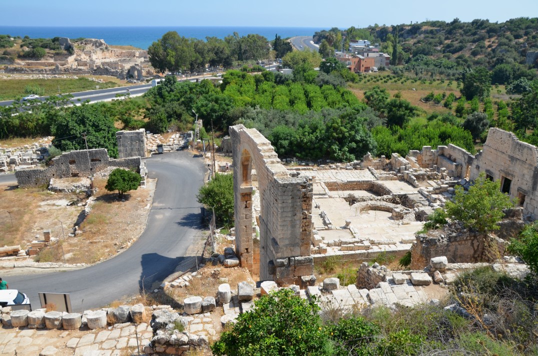
Elaiussa Sebaste was an ancient city located on the eastern coast of Cilicia, now a peninsula, 55 km west of Mersin in southeastern Turkey. The Greeks established the town in the early 1st century BC, and it later became one of the most prominent centres of Eastern Rough Cilicia. Archelaus of Cappadocia (r. 36 BC-AD 17) made the city his capital and renamed it “Sebaste” in honour of his benefactor, Emperor Augustus. The town prospered after the Cilician shores were cleared of pirates in AD 74, and it became part of the Roman province of Cilicia.
During the Byzantine period, Sebaste became a Christian city, and several churches were constructed. However, when its neighbouring city, Corycus, began to thrive in the 6th century AD, Sebaste slowly declined and fell into obscurity.
Some fascinating remains can still be found on the peninsula. These include a small theatre dating back to the 2nd century AD, an agora, a large Byzantine church, a Roman bath complex, and a temple on a hill overlooking the sea outside the city.
The theatre was built in the first half of the 2nd century AD, while its final stage may be dated to the reigns of Marcus Aurelius and Lucius Verus (AD 161-169).The theatre had a capacity of about 2,300 spectators. The orchestra was originally paved with marble slabs.The scaenae frons of the theatre, built over a sturdy ashlar structure with arches and pillars.View of the Roman Agora and Christian Basilica. The agora was built in the latter part of the 2nd century AD, and a two-apse basilica occupied its interior during the latter part of the 5th century AD.The Roman agora was a vast open area with a quadrangular plan (31.60 x 32 m), bounded on all sides by a 6.85-metre-high wall in opus quadratum made of large limestone blocks.Inside the Roman agora, there was a colonnaded portico on all four sides. They were paved in opus sectile during the Christian period.During the Early Byzantine era, the interior of the agora was entirely occupied by an imposing Christian basilica oriented east-west. It was divided into a nave and two aisles by two rows of columns.The floors of the Christian basilica were decorated in opus sectile, composed of marble and limestone tiles arranged to create various geometric motifs.Excavations within the tholos (circular structure) of the Roman Agora have revealed the remains of a polychrome mosaic featuring marine motifs.Mosaic with geometric patterns and sea animals.Broken arched bridge which was part of the aqueduct that brought water to the city from the Lamas River.Elaiussa Sebaste.The Harbour Baths complex lies on the promontory’s north-western edge on the bank of the northern port basin.The Harbour Baths were built directly against the limestone rocks of the hill and therefore do not follow the traditional plan of Roman bathing complexes. They were first built in the second half of the 1st century BC and underwent great restructuring works until the 5th century AD, when the bathing function of the complex fell into disuse.In the building’s southern section, hypocausts were brought to light.The ruins of the Byzantine Palace, built in the mid-5th century AD over the Roman fortifications.The large round courtyard of the Byzantine Palace connected the two wings of the palace.The Yemişkumu aqueduct bridges (Lamas Aqueduct) near Elaiussa Sebaste. The Lamas River, to the east of the city, provided the city’s water supply. Along the route, the water channel had to cross 7 aqueduct bridges to Elaiussa Sebaste. (Source)
Source: Silifke (Seleucia on Calycadnus ) and Environs: Lost Cities of a Distant Past in Cilicia by Celal Taşkıran (Sim Matbaasi, 1993)