Cyzicus

Cyzicus is a city of Mysia in Asia Minor built on the southern coast of Propontis (Sea of Marmara) on the isthmus of the Arctonessos peninsula near present-day Erdek in Balıkesir Province. It was founded around 680 BC by a group of Greek colonists from the city of Miletus, making it one of the oldest Greek settlements in the region. Cyzicus developed into a thriving city-state with a strong maritime tradition. Its privileged location made its two ports commercial hubs, and the city became a key hub for trade and commerce between the Greek world and the Anatolian interior. Under Roman rule, Cyzicus flourished as a prosperous urban centre. New public buildings and monuments were constructed, including a massive temple to Hadrian, considered one of the wonders of the ancient world.

Coordinates: 40° 23′ 15.91″ N, 27° 52′ 13.6″ E

According to mythology, the city was named after King Cyzicos (or Kyzikos), a Thessalian migrant who was accidentally killed by Jason. When the Argonauts journeyed to Colchis and landed on the island of the Doliones, King Cyzicos received them with generous hospitality. But after their departure, a storm drove them back to the Cyzicene coast. They landed again at night-time, but they were mistaken by the Doliones for hostile people, and a struggle ensued in which Cyzicos was killed either by Jason or Hercules. When the day broke, the Argonauts realised their tragic mistake, granted Cyzicos an elaborate burial, and celebrated funeral games (Apollonius of Rhodes 1,949).

In the early historical years, Cyzicus accepted colonists from Ionian Greeks from Miletus. The Milesian colony was established around 680 BC, when Miletus began systematic colonisation of the area. It may have begun minting electrum coins in the first half of the 6th century BC. Due to commercial activities, Cyzicene staters were used as the primary foreign currency outside the Marmara Region, especially along the Black Sea coast. The coins featured a wide variety of obverse motifs, including over 250 unique designs depicting animals, heroes, mythological creatures, and gods.

The Propontis was famous for its abundant fish, one of the main sources of wealth in Cyzicus. As early as 600 BC, Cyzicus used a tunny fish (Euthynnus alletteratus) as its civic emblem on its coinage.

Electrum stater from Cyzicus with Herakles holding club and bow with a tunny fish downwards to the left. Dated circa 550-450 BC. CoinArchives

During the Peloponnesian War (431-404 BC), Cyzicus changed hands between Persian and Athenian control several times. It became a member of the Delian League, paying an annual tax of nine talents. Sometime later (373 BC), Cyzicus joined the Second Athenian League, which it abandoned during the Allied War (357-355 BC). It remained a free city in the Hellenistic Period. It consolidated its economic domination by annexing several nearby towns, but later came under Seleucid and Pergamene control (281 BC). When the Kingdom of Pergamon was annexed by Rome in 133 BC, Cyzicus became part of the Roman world and entered a period of prosperity. It was a loyal and powerful ally of Rome in the Mithridatic Wars. When consul Lucullus won a victory over Mithridates in the Third Mithridatic War (74-67 BC) after the Siege of Cyzicus in 73 BC, he liberated Cyzicus and declared it a free city.

The city’s strategic location and economic significance made it a valuable asset for the Roman Empire, which sought to control key trade routes and resources in the eastern Mediterranean. The Romans further developed the city’s infrastructure, expanding its harbour facilities and enhancing its commercial capabilities. Cyzicus continued to mint its own coins, widely used in trade and commerce throughout the Roman world.

Cyzicus was known for its skilled shipbuilders and seafarers, who navigated the waters of the Sea of Marmara and the Aegean Sea to establish trade networks with other Greek cities and beyond. The city’s prosperity was also fueled by its agricultural wealth, as the fertile lands surrounding Cyzicus allowed for the cultivation of crops such as grain, olives, and grapes. Cyzicus was also an important centre of letters and sciences.

Cyzicus remained an important Roman city in Mysia, becoming the capital of the Hellespont province during Diocletian‘s reign (r. AD 284-305) and later, becoming part of the Eastern Empire. The city’s fate was intertwined with the invasions by barbarian tribes and successive devastating earthquakes. Because of its location on the south branch of the North Anatolian Fault zone in the Marmara Sea, the ancient city was destroyed by a series of earthquakes. Fifteen destructive earthquakes occurred between AD 29 and 1887, including one during the reign of Hadrian. The final blow was given by the Arabs, who besieged the city (AD 675), and an earthquake (AD 1063), which devastated the city completely.

Plan of the ancient city of Cyzicus.

Many ancient writers wrote about the grandeur of the ancient city of Cyzicus. Strabo thinks that “this city rivals the foremost of the cities of Asia in size, in beauty, and in its excellent administration of affairs both in peace and in war” and that “its adornment appears to be of a type similar to that of Rhodes and Massalia and ancient Carthage.” (Strabo 12.8.11). Unfortunately, Cyzicus remains the least studied and excavated city among the other major cities of Asia Minor. Little research has been done in the area, and only a few sparse ruins remain today.

Among the ruins of Cyzicus, outside the city walls and to the north, are very few traces of the 2nd-century AD Roman amphitheatre. However, on the plain outside the western walls are scattered remains of particular importance, belonging to a temple dedicated to Hadrian (perhaps originally a temple of Zeus begun by the kings of Pergamon), the city’s greatest monument. In AD 124, during his travels to Asia Minor, Hadrian visited Cyzicus. The city had just been struck by a devastating earthquake, and the emperor made large donations to help rebuild it.

The history and general character of the Temple are well-documented in literary sources. The Chronicon Paschale states that Hadrian founded a temple there and paved a marketplace with marble (Chronicon Paschale 475.10). The Byzantine chronicler John Malalas called the temple “a very large temple, one of the wonders,” with a massive bust of Hadrian on the roof and a marble stele inscribed “of Divine Hadrian” (Malalas, Chronography Bks 1-7, 10-18). Cassius Dio called it “the largest and most beautiful of all temples,” writing that “in general, the details were more to be wondered at than praised.” (Dio 70.4.1–2).

The Temple was a monumental octastyle (8 x 15) building of the Corinthian order, about as big as the Ephesus’ Artemision or Apollo’s Temple at Didyma. It measured 120 m in length and 50 m across. The sixty massive columns surrounding the cella were well over 2 m in diameter and more than 21 m high. The Temple was topped with the largest Corinthian capitals ever sculpted, one of which, 2.5 metres in height, 1.9 metres in diameter and 20 tons in weight, was unearthed in 2013.

The Temple was probably still unfinished when it was thrown down by an earthquake late in Antoninus Pius‘ reign, and was finally dedicated in 166 or 167, when the orator Aelius Aristides delivered a speech in the city of Cyzicus at a festival celebrating the restoration of the Temple of Hadrian. The most important attribute of the Temple of Hadrian, according to Aristides, was its extreme size, which made it appear ‘beyond the power of man to accomplish”, and it was this element that may have led Nicetas of Heraclea, an 11th-century Greek clergyman and writer, to compare the Temple with the Seven Wonders.

Cyriacus of Ancona, an Italian traveller and antiquarian, visited the site of Cyzicus in 1431 and reported that thirty-one of its columns were still standing (half of the original total), but the splendid ruin was being used as a stone quarry for nearby Bursa. Fifty-four years later, only twenty-six columns stood, and by the 19th century, the Temple’s superstructure was gone. Cyriacus of Ancona created detailed sketches of what remained of the Temple, which helped archaeologists recognise the Temple’s fragment among the ruins and restore the building’s plan, together with the reverses of coins showing the Temple (RPC IV.2, 11185).

An octastyle Corinthian temple with the legend neokoros (ΝΕΩΚΟΡΩΝ) begins to appear on Cyzicene coins late in the reign of Antoninus Pius. The Temple also appears on the first coins of Marcus Aurelius and Lucius Verus.

With the new Temple that Hadrian allowed to be built for his cult, the city of Cyzicus was granted the role of neokoros, temple warden of the imperial cult, joining Pergamon, Ephesus, Smyrna, and Sardis. In his Antilogy about Julian to the sophist Libanius, the 5th-century AD church historian Socrates of Constantinople states that the people of Cyzicus declared Hadrian the 13th god (Socr. Hist. Eccl. 3,23) while Antinous was also worshipped with heroic honours. Olympios was, therefore, an epithet associated with Hadrian, and there were dedications to Hadrian Olympios as the saviour and founder of the city. Linked with the city’s new status as neocoros in 124 (or later) was a Hadrianic festival called Hadrianeia Olympia, in which Aelius Aristides participated.

Base for a statue of Hadrian at Cyzicus in Mysia, naming the Emperor “Olympian, Saviour, and Founder”. (IMT Kyz Kapu Dağ 1494)
Αὐτοκράτορι Τραιανῷ
Ἁδριανῷ Καίσαρι
Σεβαστῷ Ὀλυμπίῳ
Σωτῆρι καὶ κτίστῃ.
Bandırma Archaeological Museum.
Coin of Antinous as the founding hero of Kyzikos standing in front of a horse. Minted in Cyzicus during the archonship of Claudius Euneos. Dated c. AD 130-138. (RPC III, 1528)

The Temple is today represented only by the substructures of the podium, with fragments of decorative and architectural elements scattered around, including marble roof tiles measuring 105 x 85 cm, marble gutters with lion heads, and the largest Corinthian capitals ever sculpted. While excavation works continue at the Temple of Hadrian, numerous stone objects have been found, including sculptures from the Temple with traces of red and blue paint and gold gilding.

Sculptures unearthed at the excavation site of Hadrian’s Temple (AA Photo).

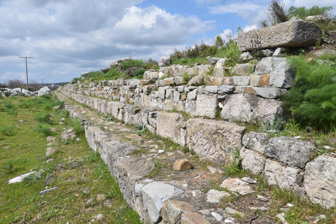
An exceptionally large amphitheatre was situated in the valley on both sides of the sloping hills beneath the Acropolis. Its elliptical shape may be traced from the few pilasters and arches rising from the thickly wooded slopes of the old cavea. As at Pergamon, a small stream flowed through the building, presumably for use in naumachiae (naval spectacular displays) and for the cleansing of the arena. The amphitheatre was oval and surrounded by two tiers of arcading. There were originally thirty-two vomitoria (entrances). The central axis measured around 140 meters. Hadrianic inscriptions found among the ruins of the amphitheatre have allowed its dating in the reign of Hadrian.

PORTFOLIO

Panoramic view of the isthmus of the Arctonessos peninsula.
The steps of the podium of the Temple of Hadrian. The Temple was set on a high platform c. 80 x 140 m.
The most recent attempt at reconstructing the basic plan produces a huge octostyle temple measuring 46 x 90 m, with sixteen Corinthian columns reaching 21.3 metres in height and 2.3 metres in diameter.

Vaulted structures at the northern end of the Temple of Hadrian.
Remains of dependencies at the northern end of the podium of the Temple of Hadrian.
The Temple was topped with the largest Corinthian capitals ever sculpted, one of which, 2.5 metres in height, 1.9 metres in diameter and 20 tons in weight, was unearthed in 2013.
The largest Corinthian capital known to date.

Fragments of decorative and architectural elements of the Temple of Hadrian.
Fragments of decorative and architectural elements of the Temple of Hadrian, including a gutter with a lion head.
Column drum from the Temple of Hadrian.
Corinthian capital from the Temple of Hadrian.

Fragment of a vine-wreathed column from the Temple of Hadrian at the nearby Erdek Açık Hava Müzesi.
Fragments of decorative and architectural elements of the Temple of Hadrian.
Gutter with a lion head from the Temple of Hadrian at Cyzicus in the Erdek Açık Hava Müzesi.
Panoramic view of Cyzicus with the amphitheatre in the distance buried and invaded by a dense forest.
Pilasters of ashlar belonging to the amphitheatre of Cyzicus.
Remnant of the biggest pilaster of the Roman amphitheatre, one of the two superstructures that formed the amphitheatre’s main door.
View from the arena of the amphitheatre.
The small stream that flows through the building was presumably used for spectacular naval displays (naumachiae).
Gravestone of the provocator Euprepes found in Cyzicus. (IMT Kyz Kapu Dağ 1418)

Links:

Nicaea

Nicaea is an ancient Greek city in the northwestern Anatolian region of Bithynia, now the modern Turkish town of İznik. It is most notable as the site of the First and Second Councils of Nicaea. The city was founded by Antigonus I Monophthalmus, one of Alexander the Great‘s generals, around 316 BC, and initially served as a strategic military outpost. Over time, Nicaea evolved into a prominent cultural and economic centre within the Bithynian Kingdom. Its location on the eastern shore of Lake Ascanius (modern-day Lake İznik) provided both strategic advantages and fertile land, contributing to the city’s prosperity. Hadrian took an active interest in Nicaea, visiting the city after an earthquake in AD 120. The city was the hometown of the Greek astronomer Hipparchus and the Roman historian Cassius Dio.

Coordinates: 40° 25′ 44.4″ N, 29° 43′ 10.2″ E

Nicaea is said to have been colonised by Bottiaeans from Central Macedon, who had named the city Helikore, but the Mysians subsequently destroyed the first colony. In the wake of Alexander the Great’s death, Nicaea was rebuilt by the Macedonian king Antigonus I, who named the city Antigoneia after himself. Shortly after that, in 301 BC, following the battle of Ipsus, Lysimachus conquered the town and renamed it Nikaea in honour of his wife. In 281 BC, the area gained independence from the Seleucids, and Nicaea came under the control of the local dynasty of the kings of Bithynia. Gradually, the Romans extended their control in the region, and in 74 BC, the last Bithynian ruler bequeathed his province to Roman authority.

Nicaea became particularly significant during the Hellenistic and Roman periods. The city played a pivotal role in the Hellenistic wars and was later incorporated into the Roman Empire in 74 BC. Under Roman rule, Nicaea flourished as a hub for trade and commerce, benefiting from its proximity to major trade routes. It gained prominence as a key administrative and religious centre, hosting important imperial conferences and councils.

Iznik’s central square, with the clock tower (İznik saat kulesi) presiding over the town’s crossroads, next to Hagia Sophia.

As Strabo records (Strab. 12.4), the town was built as a square measuring 16 stadia in circumference (approx. 700 sq. km). The city’s streets were planned using the Hippodamian system, with all intersections at right angles. This system is still visible in Iznik’s modern street layout. The city had two main streets leading to four gates, visible from a fixed stone at the centre of the gymnasium, which stood at the heart of the town. During the Hellenistic Period, Nicaea had a smaller ring of walls, as Strabo noted. The Hellenistic walls fell into disuse and disappeared in the Roman period. Instead, freestanding triumphal arches were built under Vespasian at the ends of Nicaea’s main streets. After the Goths threatened the region in the late 3rd century AD, the city walls were reconstructed. These walls formed an irregular pentagon measuring about 5 km on a side, as seen on the reverses of bronze coins minted under the emperors Valerian and Gallienus.

Map of Nicaea.

Nicaea was embellished under Augustus to the point of contending with Nicomedia for the seat of the provincial governor. A temple dedicated to Roma (the personification of the city of Rome) and Julius Caesar was erected. Furthermore, in this same period, the koinon of Bithynia instituted agonistic games in Nicaea, held every four years in honour of the Emperor.

Caesar, meanwhile, besides attending to the general business, gave permission for the dedication of sacred precincts in Ephesus and in Nicaea to Rome and to Caesar, his father, whom he named the hero Julius. These cities had at that time attained chief place in Asia and in Bithynia respectively. Dio 51.20.6

During the Flavian period (after AD 70), four new monumental gates (north, east, west and south) were built from local marble and dedicated by the Bithynian proconsul. They honoured Vespasian and his son Titus and “the first city of the province, Nicaea”. Each gate had an arched central passage flanked by two minor rectangular gateways. They were embellished with statues in the niches on either side of the archway and perhaps over the gates. Later, in the 3rd century AD, as part of a re-fortification project, the walls were raised, and the gates were entirely rebuilt with a new brick superstructure and towers.

Pliny the Younger, governor of Pontus and Bithynia under Trajan, played a significant role in developing and expanding the city of Nicaea. During his tenure, he corresponded with Trajan on the state of public works in the city. Pliny reported on the progress of various unfinished buildings, including the theatre and the gymnasium (Plin. Epist. 10.39).

Nicaea was devastated by an earthquake in AD 120, which caused extensive damage. Hadrian contributed to the city’s rebuilding by providing it with new colonnaded streets and a market and repairing the city walls on a much larger scale. In honour of his benefactions and his visit in 124, Nicaea’s northern and eastern gates would be rededicated to Hadrian (IK Iznik 29).  Another inscription (AE 1939, 293) indicates that Hadrian was the dedicatee of the Nicaea aqueduct and that he enforced strict land-use regulations around the aqueduct. Under Hadrian, Nicaea became a neokoros for the first time and was awarded the title metropolis, as evidenced by the long dedication to Hadrian on both sides of the architrave of the gates.

After an earthquake had happened, Nicomedia lay in ruins, and many things were overturned in the city of Nicaea: for the reconstruction of which, Hadrian generously gave funds from the public treasury. Jerome, Chronicle 180

Reconstruction of the Lefke Gate (East).

The city’s historical significance reached a zenith in AD 325 when it hosted the First Council of Nicaea, convened by Constantine the Great. This ecumenical council aimed to address theological disputes within Christianity and led to the formulation of the Nicene Creed, a seminal statement of Christian faith. The impact of this council resonates through the annals of Christianity, solidifying Nicaea’s place in religious history. Another important council was held in AD 787 to deal with the iconoclastic controversy. This would be known as the Second Council of Nicaea and the Seventh Ecumenical Council.

The Byzantines further fortified the city, leaving remnants of defensive walls and structures that testify to its strategic importance. However, the city experienced several destructive earthquakes over time. In AD 740, a powerful earthquake caused significant damage to Nicaea, leading Emperor Constantine V (r. AD 741–775) to initiate extensive reconstruction projects in Nicaea and throughout the region.

After the sacking of the Byzantine capital, Constantinople, during the Fourth Crusade, Nicaea became the capital of the Empire of Nicaea and the Patriarchate’s seat until the collapse of the Latin Empire in 1261. Nicaea fell to the Ottoman Turks in 1453. Renamed Iznik, the town gained worldwide renown as the centre of ceramic tiles and pottery production, one of the most beautiful and enduring types of Turkish-Islamic art (see here). Iznik tiles are a type of ceramic tile used in architectural applications for private residences since the late 15th century. These tiles are known for their beautiful and intricate designs and patterns, often featuring blue and white floral or geometric motifs.

A map indicating the division of the Byzantine Empire following the sack of Constantinople in 1204 CE during the Fourth Crusade.
Author: LatinEmpire (Wikimedia)
Despite seismic events, İznik’s ancient structures, such as the city walls, among the best-preserved fortifications of Anatolia, a theatre, and the Hagia Sophia, which housed the Second Council of Nicaea, still stand today. These remnants offer a testament to the city’s inhabitants’ resilience and to the natural forces that have shaped its historical landscape.

Excavation and restoration work at Pliny’s theatre has been carried out by Dokuz Eylül University’s archaeology department since 2016. The theatre, which is the only one in Turkey that rises on vaults in a flat area, has a seating capacity of approximately 10,000 spectators. During the reign of Hadrian, two-story columned galleries were constructed on both sides of the stage building, independent of the theatre. The galleries of the second floor were decorated with statue herms standing between the columns and parapets. The theatre was used for gladiatorial games, as evidenced by the sword-shield relief on the analemma wall and the gladiator oil lamps found during excavations. Further excavations have revealed that the theatre was later transformed into a mass graveyard in the 13th century. During the Ottoman period, ceramic kilns were discovered within the ancient building, and its stones were used as construction materials, particularly in rebuilding the city walls during the Byzantine and Ottoman periods.

The Roman Theatre of Nicaea.
www.gotobursa.com.tr

In 2014, during a seasonal drought when the lake was at a low level, the remains of a basilica church were discovered just outside the city walls, approximately 50 metres from the shore. This basilica is believed to have been built in memory of Saint Neophytos, who was killed during the Christian persecution led by DiocletianAccording to researchers, the basilica may have been built in response to the First Council of Nicaea, convened by Constantine the Great in 325. The basilica became submerged after an earthquake in AD 740. The discovery of the basilica was included in the Archaeological Institute of America’s list of the top 10 archaeological discoveries of 2014.

Nicaea is well known for its necropolises surrounding the city. The Hisardere Necropolis is one such necropolis situated 2.4 km from the city centre on a 10,400 m2 land that includes vineyards and olive groves. The area has been subjected to rescue excavations, revealing numerous sarcophagi and terracotta cist burial chambers, including the Sarcophagus of Gregorios, the Sarcophagus of Achilles, the Sarcophagus of Antigonus and the Sarcophagus of Nike and Eros. These sarcophagi can be viewed at the new Iznik Archaeological Museum.

The sarcophagi room of the new Iznik Archaeological Museum.

Just outside Nicaea, along the ancient road to Nicomedia, stands the funerary monument of Gaius Cassius Philiscus, a wealthy landowner from Nicaea who died at 83. Another funeral monument can be seen north of Iznik, where 17 pieces from a burial chamber carved from basalt rock, known as “Berber Rock” by locals, are scattered on a slope near the district’s Lefke Gate. The tomb dates back to the Bithynia civilisation in 149 BC. In 1990, a beautiful relief of Hercules was discovered in an ancient stone quarry known as Deliktas, just outside of Iznik. This relief may be related to the mythological foundation of Nicaea, as the hero Herakles is said to have founded the city.

İznik is on the UNESCO World Heritage Site Tentative List.

PORTFOLIO

Lake Ascanius (Lake Iznik)

Nicaea was located at the eastern shores of the lake Ascanius in a fertile basin. The lake is around 32 km in length and 10 km in width, with a maximum depth of about 80 m.
In Greek mythology, during the Trojan War, the region by Lake İznik was held by the Phrygians, who sent troops to the aid of King Priam, led by the brothers Phorcys and Ascanius, sons of Aretaon as related in the Iliad.
The fertile plain around Lake Ascania.

The Gates and City Walls

The Istanbul Gate (northern gate), with the Flavian arch, was integrated into Nicaea’s Byzantine fortifications. The gate connected the city to the Nicomedia and Byzantium/Constantinople road.
The Northern (Istanbul) Gate originally consisted of a simple gate with an arched central passage flanked by two rectangular minor gateways, built by Bithynian Proconsul Marcus Plancius Varus during Vespasian’s reign in the second half of the 1st century AD with financial support from Gaius Cassius Chrestos of Nicaea. The arch was built from local marble.
The northern arch was repaired and renovated with financial support from Hadrian following the earthquake of AD 120.
The imperial arch was incorporated into the city gates and walls, built in the 3rd century AD under the reign of Gallienus (r. 253-268) and completed under Claudius Gothicus (r. 268-270) when the region was threatened by the Goths. The present inner wall dates back to this latter phase, although it has undergone many restorations and rebuilding following earthquakes and sieges up to the 11th century.
During the reign of John III Doukas Vatatzes, Emperor of Nicaea from 1221 to 1254, the walls were strengthened with a second circle, concentric to the former, in an arrangement that was inspired by the Theodosian walls of Constantinople.
The Lascarid (13th century AD) outer wall of the Northern (Istanbul) Gate (northern gate) is faced with spolia ( re-used stones from Roman sarcophagi). The second entrance gate is decorated with two marble masks,
recovered from the Roman theatre of the city.
Lake (Göl) Gate with portions of walls still visible.
Lake (Göl) Gate with portions of the towers still standing.
The Eastern (Lefke) Gate.
The Eastern (Lefke) Gate, as seen from the outside, with a series of three gates. It marked the main road to Ancyra and Central Anatolia.
The Flavian arch was integrated into Nicaea’s Byzantine fortifications. It was built by the Bithynian proconsul Marcus Plancius Varus during Vespasian’s reign. The arch has two similar inscriptions dedicated to Vespasian and Hadrian on each side of the city gate.
The original bronze letters are lost, but the inscription over the east (Lefke) gate can still be deciphered. The inscription of gratitude to Hadrian for rebuilding the gate after the earthquake (IK Iznik 1) is the lower one on the architrave.
The Eastern (Lefke) Gate, as seen from the inside. It marked the entrance to Nicaea from the east. The gate consists of a triple entrance system, as in the Istanbul Gate, which includes the Roman triumphal arch.
The arch was embellished with statues standing in the niches.
The 13th-century AD outer walls of the Eastern (Lefke) Gate twin towers flanking the gate and displaying an extensive use of spolia.
Right next to the Lefke Gate are the ruins of the Roman aqueduct, restored and repaired many times over the centuries and then filled and converted into walls.
The aqueduct’s total length continuously visible on the field amounts to about 1.5 km. The aqueduct was originally built using a framework of terracottas and limestone rubble.
The building visible today was built during the reign of Hadrian and restored at the time of Justinian, according to Procopius (De aedificiis, V, 3). Restorations were also done by Theodore I Lascaris (1205–1222) in the 13th century.
The Southern (Yenisehir) Gate, with a Roman arch dating to the Flavian era, was the south entrance gate of Nicaea, on the road connecting the city to the other cities in Bithynia (Prusa ad Olympus and Apameia).
The function of the Yenişehir Gate changed after this period ended upon the invasion of the Goths. The imperial arch was united with the fortification walls built in the 3rd century AD and was converted into a defence structure.
A second fortification line was built in front of the existing wall line to strengthen the defence structures in the 13th century. A tower was built on both sides of the gate.
Nicaea’s Byzantine fortifications.
The 5km-meter-long city walls had 12 secondary gates and 114 towers, about 60-70 metres apart.
Nicaea’s Byzantine fortifications.

The Roman Theatre

The Roman Theatre of Nicaea was built during the reign of Trajan. Archaeological excavations revealed a church, palace, Ottoman ceramic workshops and tile kilns were constructed within it. The theatre is still being excavated and restored.
Located in the southwest part of the city between the lake and Yenişehir Gate, the theatre was largely built on vaulted substructures in opus caementicium and was faced with marble.
The word-shield relief on the analemma wall of the theatre shows that gladiatorial games were held in the theatre in the 2nd and 3rd centuries AD.

The Hagia Sophia

The Hagia Sophia is the site of the Second Council of Nicaea. It was originally a basilica built by Justinian in the 6th century over the ruins of the former church dating back to the 4th century AD.
Hagia Sophia was demolished after an earthquake in the 11th century. The church was rebuilt as a basilica with three naves. The church is still located where the roads leading to the four main gates in the district centre meet.

The Beştaş Obelisk

Outside Nicaea, on the ancient road to Nicomedia, rises the funeral monument of Gaius Cassius Philiscus, a wealthy Nicaean landowner who died at the age of 83. The obelisk, triangular in section, is 12 m tall and is placed on a rectangular base.
The Beştaş Obelisk was probably a family grave. It is believed to have been built in the 1st or 2nd century AD and surmounted by an eagle or a Victory.

Stone relief of Hercules

The unfinished relief of Hercules was carved into a stone block in a quarry outside of Nicaea in the 3rd century AD.
The relief is life-size and is placed inside a niche cut into the rock. However, the details were left untreated, and the surface was not polished, showing it was unfinished. It is believed that the relief was carved to protect the quarry workers.

Basilica of Saint Neophytos 

The Basilica of Saint Neophytos was probably built shortly after the Ecumenical Council of AD 325 but became submerged by the lake after an earthquake of AD 740 and was only rediscovered in 2014.

Berber Kaya

Berber Kaya is a mausoleum of the 2nd century BC located on the hillside of Nicaea. It was destroyed in 1953 by tomb robbers who broke it with dynamite.
The funeral monument was carved from a single piece of basalt rock.

Links:

  • The Princeton Encyclopedia of Classical Sites: NICAEA (Iznik)
  • Stefanidou, Vera (2003). “Nicaea (Antiquity)“. Encyclopaedia of the Hellenic World, Asia Minor. Foundation of the Hellenic World.